javascript

Google map of London with Flickr shape data overlaid

November 16th, 2008  |  Published in javascript

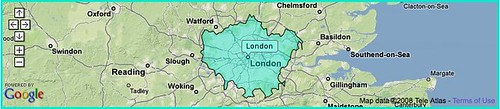
Flickr place info now includes shape data for many places. See the Flickr code blog for more.

We’ve correlated most of Dopplr’s places with Yahoo WOE IDs using Flickr’s reverse geocoder, so we can use this data too. As an experiment, I wrote some clientside code to overlay this shape data onto the maps we use on Dopplr. Help yourself to the code if you want it: gist.github.com/25502

Dodgy SVG version of picdiary slides page

December 23rd, 2002  |  Published in foaf, javascript, photos, svg, wordnet

I felt it was time to learn a bit more about SVG and do some concrete work with it. I made a fairly simple SVG document that renders picdiary feeds. It parses the RSS and builds the page on the client-side using Jim Ley’s lovely javascript rdf parser.

Compare the HTML version to the SVG version. There’s nothing in the SVG version that couldn’t be rendered in HTML; the interest was in doing the job entirely client-side.

Read the rest of this entry »